USA Albers Equal Area Projection Map - Import Images
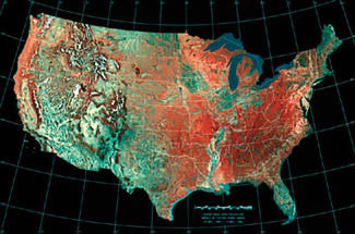
Mosaic of Fifteen AVHRR Images
24 May, 1984 - 14 May, 1986
Add the most accurate-possible area map of continental America to your wall! Using the Albers method, this poster gives you a bird's-eye satellite view of the USA, with every state appearing in precise proportional size to each other. The major mountain ranges, plains, and river valleys are visible through colorful shading, and the state borders are marked in white. Perfect for any lover of the greatest country on earth!
Poster Specifications:
Product Information
Product Information
Shipping & Returns
Shipping & Returns
USA Albers Equal Area Projection Map - Import Images
USA Albers Equal Area Projection Map - Import Images
Mosaic of Fifteen AVHRR Images
24 May, 1984 - 14 May, 1986
Add the most accurate-possible area map of continental America to your wall! Using the Albers method, this poster gives you a bird's-eye satellite view of the USA, with every state appearing in precise proportional size to each other. The major mountain ranges, plains, and river valleys are visible through colorful shading, and the state borders are marked in white. Perfect for any lover of the greatest country on earth!
Poster Specifications:
Original: $19.95
-70%$19.95
$5.98Product Information
Product Information
Shipping & Returns
Shipping & Returns
Description
Mosaic of Fifteen AVHRR Images
24 May, 1984 - 14 May, 1986
Add the most accurate-possible area map of continental America to your wall! Using the Albers method, this poster gives you a bird's-eye satellite view of the USA, with every state appearing in precise proportional size to each other. The major mountain ranges, plains, and river valleys are visible through colorful shading, and the state borders are marked in white. Perfect for any lover of the greatest country on earth!
Poster Specifications: